Lake Blanche, in the Twin Peaks Wilderness of the Wasatch range, is a lovely alpine lake that entices hikers to linger and enjoy its beauty.

Chris & Mac
We outventure to help you outventure!
For us, outventuring isn’t just about adventure. It’s about the quiet moments — the first light on a ridgeline, the sound of a creek at camp, the shared laughter when the trail gets spicy. We believe the outdoors enriches people’s lives, and we want to help more folks experience that connection. Learn more about us HERE.
Scroll down for full slideshow.
Length: Approximately 7 Miles Round Trip
Trailhead(s): Mill B South Trailhead
Elevation Gain: 2,800′
Trail Type: Out & Back
Dogs: Not Allowed
Difficulty: Moderate to Strenuous
Permit Required? No
Considerations: No bathing or swimming in lake
Season: Summer to Fall (Best)
Overview
Searching for a Salt Lake City area hiking adventure? How about a hike to a lovely alpine lake? Up for some serious, but manageable, elevation gain? If so, then plan a hike to Lake Blanche. This gorgeous alpine lake is a gem, and the payoff is worth every bead of sweat it takes to get there.
LAKE BLANCHE
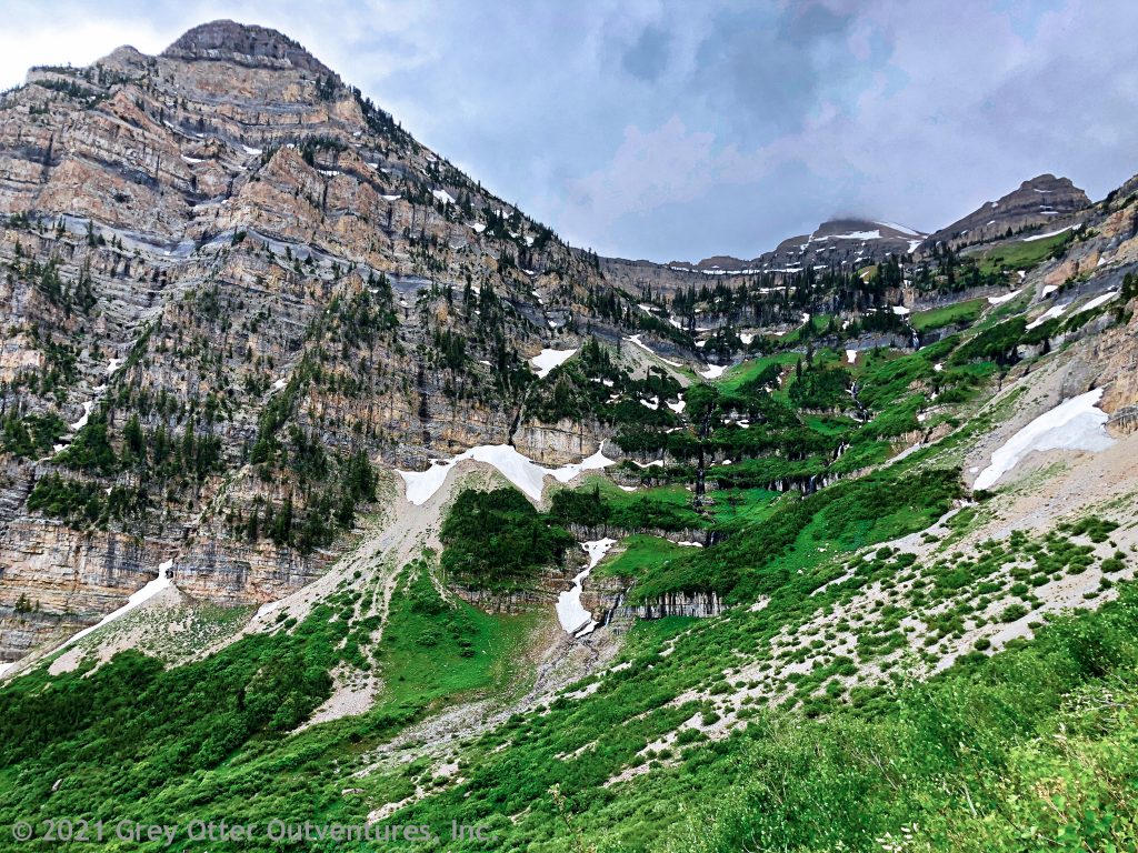
Lake Blanche lies in the Twin Peaks Wilderness area of the Wasatch Mountains at an elevation of just under 8,900 feet. A typical high alpine glacial lake, Lake Blanche is a big bowl of crystal clear water nestled beneath magnificent mountain peaks. For those who venture up to see it, the memory will linger because Lake Blanche is breathtakingly beautiful.
With Sundial Peak and Dromedary Peak both looming above and perfectly reflecting in it, the scene at Lake Blanche is enticingly serene. In fact, upon arrival after the hike up, nearly everyone just stares in awe at its quiet beauty. Brilliantly reflecting all of the trees, rocks, ridges and peaks lying beyond and around it, the clear waters of Lake Blanche are enchanting.
Additionally, the setting around Lake Blanche is also a joy to behold. At one end of the lake, a majestic chunk of rock protrudes sharply into the sky. This is Sundial Peak. Beyond it, the high ridge connecting Mt. Superior and Dromedary Peak adds a dramatic touch to the picturesque lake below. Until it melts, snow clinging to this ridge adds more interest and texture. Lastly, colorful wildflowers peek out from the rocks during the summer to put the finishing touches on this picture perfect landscape.
MILL B SOUTH TRAILHEAD PARKING & LAKE BLANCHE TRAIL
The Mill B South Trailhead parking area is fairly large. However it can fill quickly because it serves as the starting point for two popular trails. Consequently, snag a parking spot by arriving early and/or avoiding weekends during the busy summer months.
Lake Blanche Trail
Departing the Mill B South Trailhead (near the restrooms), hikers to Lake Blanche start off on a paved trail which follows Big Cottonwood Creek. After about .2 miles, the Lake Blanche Trail is easy to spot as it leads off to the the right. After roughly another .2 miles this well worn dirt trail crosses the Mill B South Fork Creek and begins heading steadily upwards.
For the first couple of miles the hike is pleasant. About half of the elevation gain gets knocked out while the trail loosely follows the Mill B South Fork Creek. Some mountain views through the mix of pine and aspen entice hikers to keep going.
After just under two miles the trail diverges from the creek below a huge rock basin. The creek flows down from a non-navigable wall of rock whereas the trail takes hikers up through a manageable boulder field. Upon finishing the climb through the boulder field, the enormous rock basin is revealed. Sitting in it is lovely Lake Blanche.
If time allows, further exploration of the Mill B South Fork Creek reveals more of this gorgeous basin.
Mill B South Fork Creek
We often follow creeks which more or less lead us directly to the shore of a lake. This is not the case, however, with the Lake Blanche Trail and Mill B South Fork Creek.
The Mill B South Fork Creek is borne of snowmelt from Mt. Superior. The melt follows a smaller ridge off of Mt. Superior that terminates at Sundial Peak. It then flows down into the rock basin where Lake Blanche sits. As it makes its way downward through the large rock basin, however, the Mill B South Fork Creek fills not only Lake Blanche, but two other lakes as well.
Lake Florence, and Lake Lillian
After exiting Lake Blanche, the Mill B South Fork Creek carves a path downward. Its next destination is Lake Florence. Nestled further down in the basin, Lake Florence is surrounded by rock and is the smallest of the three lakes. To get to Lake Florence simply follow the footpaths to the right (west) on the rocks above Lake Blanche. The rock basin does not end at Lake Florence, however, and neither does the creek. Continue following the paths on the rock around the lake to get to Lake Lillian.
All footpaths eventually terminate at the far end of Lake Lillian. This lake marks the end of the rock basin. Once it overflows Lake Lillian, the creek finally escapes the basin to flow through the valley where it merges with Big Cottonwood Creek near the trailhead.
Do not attempt to follow the creek down from the basin! Follow the footpaths back to Lake Blanche and get back on the trail down through the boulder field to return to the trailhead.
Scroll down to learn about the GEAR WE USE and OTHER OUTVENTURES in this area.
Additional Information (Click below to follow links.)
Lake Blanche Slideshow
(Click image to expand.)
Gear We Use for Day Hiking
To see descriptions of the gear Chris & Mac use for day hiking, as well as links to manufacturers and retailers offering the gear for sale, please CLICK HERE.
Articles About Other Regional Outventures that May Interest You (click to view):
SAFETY DISCLAIMER: The activities discussed in this website are outdoor activities and, as such, have inherent risks to which participants are exposed. It is not the intent of this website, nor is it possible due to the variability of weather, terrain, equipment, and experience, to detail all of those risks. The information contained in this site is informational, but not instructive nor exhaustive. It is the sole responsibility of the user to ensure he/she is in good health, fully prepared, and fully informed as to dangers before undertaking any of the activities discussed in this website and the user does so at his/her own risk. The user understands that by using this website he/she acknowledges and accepts all risks associated with use of information from this website and participation in any particular activity addressed herein. Please see “Terms of Use” for additional information.
Want to share this article with your friends? Click on the share button below:
Want more?
Get the latest outventure updates by following us on social media . . .