The majestic beauty of Oregon’s Eagle Cap Wilderness surrounds backpackers hiking the Aneroid & Lakes Basin loop in the Wallowa Mountains.

Chris & Mac
We outventure to help you outventure!
For us, outventuring isn’t just about adventure. It’s about the quiet moments — the first light on a ridgeline, the sound of a creek at camp, the shared laughter when the trail gets spicy. We believe the outdoors enriches people’s lives, and we want to help more folks experience that connection. Learn more about us HERE.
Scroll down for full slideshow.
Length: 37.4 Mile Loop
Trailhead(s): Wallowa Lake Trailhead
Elevation Gain: 6,983’
Trail Type: Loop
Dogs: Allowed
Difficulty: Moderate to Difficult
Permit Required? Yes; Free Wilderness Permit – Self Issue at Trailhead
Considerations: Heavy Usage in Summer; Snow May Linger Into July
Season: Summer & Fall
Overview
Oregon’s Eagle Cap Wilderness is the crowning jewel of the Wallowa Mountains. The magical beauty hidden deep within the Eagle Cap Wilderness is revealed not only in one of its most popular areas, but beyond it as well. For a backpacking trip that exposes it all, head first to Aneroid Lake and then over to the Lakes Basin. We promise, you will not be disappointed by the amazing scenery.
WALLOWA MOUNTAINS EAGLE CAP WILDERNESS
Located in Northeastern Oregon, the 556 square mile Eagle Cap Wilderness encompasses nearly all of the Wallowa Mountain Range. With over 500 miles of developed trails it is a fantastic place to explore. Exquisite granite peaks, picturesque alpine lakes, tranquil meadows, babbling creeks, and beautiful valleys all lie within its boundaries. It is no wonder that so many are drawn to this place.
However, anyone doing a day hike in the Eagle Cap Wilderness can only scratch the surface, so to speak, of what it has to offer. The best parts are located far from developed trailheads. This makes them inaccessible for day adventurers, but well within the reach of those who go backpacking.
The Eagle Cap Wilderness is truly a backpackers paradise. The further into it one goes, the better it gets. This is especially true when visiting the Lakes Basin.
ANEROID LAKE – LAKES BASIN LOOP
The Lakes Basin in the Eagle Cap Wilderness of the Wallowa Mountains is beautiful. There is so much to see in this wilderness, however, that we encourage taking the time to go beyond the basin. Why bother? Because the spectacular scenery beyond the boundary of this hugely popular area is absolutely worth your time and effort.
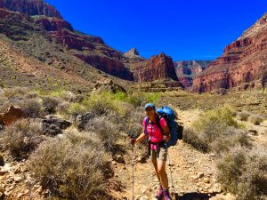
Our backpacking adventure through the Wallowa Mountains took place over four days. Instead of heading directly to the Lakes Basin for a couple of days like many do, our loop first took us to Aneroid Lake. From there we summited Polaris Pass and then dropped into the Lakes Basin. This route is not for everyone, but we absolutely loved it. Not only did we get into the beautiful Lakes Basin, we saw incredible sights we saw we would not have otherwise seen in the Eagle Cap Wilderness.
East Fork Wallowa Trail #1804 to Aneroid Lake
Fill out a free Wilderness Permit at the trailhead and head for Aneroid Lake on the East Fork Wallowa Trail #1804. Although rocky, the trail is easy to follow and not overly technical. Following the path of the East Fork of the Wallowa River up to Aneroid Lake, the sight and sound of it is never too far away. At one point the trail crosses it via a footbridge.
Trees surround the trail for most of the hike up to Aneroid Lake. Except for some views of Wallowa Lake a short ways up on the trail there are no great views of the mountains. Tantalizing peeks at granite through the trees and over the tree top deepen our determination to get to where we can see them. However, to see what at this point we can only imagine we must get out of the trees. That happens at Aneroid Lake.
Aneroid Lake is thus a popular destination for day hikers for two reasons. One, this beautiful lake is close enough to the trailhead to reach on an out and back hike. Two, the gorgeous treasures hiding behind the trees are on full display here.
Aneroid Lake
The trail does not pass directly by the shore of the lake, so backpackers must leave the trail to find the campsites. At Aneroid Lake a marked spur trail leads to them.
Reaching the lake we find and set up on a lakeside site with commanding views of the lake and surrounding area. Other than a few day hikers and one other backpacking couple we observe at the far end of the lake, we have the place to ourselves. We get comfortable, pull out our lunches, and spend the rest of the day blissfully soaking in the scenery.
This beautiful lake is captivating for a couple of reasons. First, rising sharply above the shore opposite the campsites stands a gorgeous stretch of white granite dotted with vegetation. Beyond it rises a massive wall of red rock completely devoid of vegetation. The white granite provides an excellent example of a truism we have witnessed many times. Wherever life can take hold, it does. At Aneroid Lake, and throughout the Eagle Cap Wilderness, we see many examples like this of nature’s determination to endure.
In late September the scrubby foliage holding firm to the rock was sporting a fierce mix of red, orange, and gold that contrasted brilliantly against the granite. This scene burned itself into my memory. So did the sight of the sunlight which shined brightly on the red rocks as the sun set that night and rose the next morning.
Aneroid Lake to Polaris Pass
The most incredible scenery on our adventure in the Eagle Cap Wilderness occurred on day two while hiking from Aneroid Lake to Frazier Lake. The sheer beauty of what we saw stopped us in our tracks more than once.
Regaining the East Fork Trail at Aneroid Lake, it ascends through the trees at the far end of the lake. Emerging from the trees following this climb, it runs below the gorgeous red rock with the sheer face. The transition from trees to open grassy meadows is quick. Through the meadows the trail flattens out and then climbs gently to Tenderfoot Pass. The valley and meadows have lovely views all around. Soon after Tenderfoot Pass the trail intersects Polaris Trail #1831. As we bid Tenderfoot Pass farewell we wonder what the next pass will bring.
To our delight, we discover that the climb up to Polaris Pass is incredibly gentle and that the rolling hills behind us are awesome. We stop several times to turn around, and we’re getting a little giddy. The way up is not horrible, and the views are jaw dropping. We continue up, eager to see what’s on the other side of the pass.
Polaris Pass
Upon reaching the top of Polaris Pass we are blown away. Not because it’s windy. No, it is because everything on both sides of the pass is visible, views are endless – and completely different
Hiking up to Polaris Pass we walked on rock embedded in soil surrounded by low vegetation sporting the colors of fall. As we neared the top the trail got rockier, the rocks got smaller, and the vegetation thinned. In contrast, the trail on other side of the pass is a thin ribbon of trail cutting through rocky scree devoid of any vegetation. It was like this for as far as we could see. We knew that it would be a long, slow hike down.
Even though we cannot see where the trail goes, we don’t care. Everything we see before us is unbelievably huge, and we are utterly mesmerized. From Polaris Pass it is obvious that we are heading towards a beautiful, lush green valley. Above it an endless line of towering jagged peaks capped with snow fills the horizon. Thanks to the many switchbacks taking us down from Polaris Pass, we get to enjoy this view of the Eagle Cap Wilderness for a very long time.
Descending Polaris Pass
Heading down the sketchy scree trail from Polaris Pass affirms our choice of direction. Climbing down loose rock requires careful attention to footing, but climbing up it is just plain hard. Although we encounter some sketchy patches, close attention to our footing allows us to move safely through this enormous scree field.
Eventually we find firmer footing as we exit the scree. As soon as we find terrain stable and wide enough for us to drop our packs it is time for a much needed lunch break. Still well above the valley floor, we chow down and are happy to have the worst of the steep descent behind us.
Shortly before we reach the valley floor we find ourselves standing beside flowing water. If water is needed, this is the the first access to it – 9.25 miles from Aneroid Lake.
Getting to Frazier Lake
Once down in the lush valley we soon reach the junction with the West Fork Trail #1820 and are now “officially” on the Lakes Basin Loop. Heading left towards Frazier Lake, the West Fork of the Wallowa River flowing out of Frazier Lake accompanies us on our journey. The trail follows it up, and it is a pleasant change to hear flowing water and see the pretty vegetation surrounding the river.
Tired but still stoked, we have more climbing to do and a couple of additional miles to travel before reaching Frazier Lake. Fortunately the scenery and river are pleasant company because just before reaching the lake the trail tortures us with one last very steep stretch. Fortunately it does not last for long and we forget all about it because we are done for the day. Seven hours after we set out from Aneroid Lake we arrive at Frazier Lake.
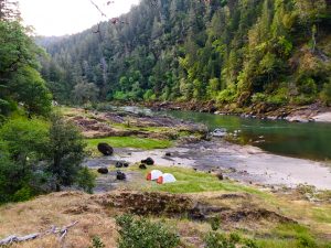
Frazier Lake
We depart the trail on the first footpath that leads down to an open area next to the lake. Unfortunately it had zero privacy for camping, but would be a great place to hang out to enjoy the lake. Following it to the left we soon came upon a nice area perfect for two tents.
After setting up camp and laying our sweat soaked gear on rocks and logs to dry in the sun, we grabbed our chairs and headed back to the open area to enjoy the lake. A nice pile of rocks nearby made a lovely perch for gathering water.
It got cold as soon as the sun went behind the mountains. Fortunately the meadow behind our campsite still had plenty of sunshine so we relocated there to stay warm for a little while longer. Once again, we enjoyed a lovely sunset. When there was no more sunshine it was time to get ourselves fed. As soon as we were done it was time to escape the plummeting temperature by calling it a day. We blissfully lay our tired bodies down for a long rest.
Glacier Lake Trail to Glacier Pass
The forest service map overlay we used on our tracking app had the Glacier Lake trail junction to Glacier Lake and Glacier Pass incorrectly marked. After tracking up and down the trail for a half hour scouring the hillside above the lake looking for this trail where it was indicated, we finally found it at the other end of the lake. It is a well marked intersection. We begin climbing.
The best part of getting to Glacier Lake from Frazier Lake is the gorgeous glacial valley that lies between them. The trail ascends gently to Glacier Lake through it, and then flattens out as it passes by the lake. Once it starts ascending again we are on rocky switchbacks that take us quickly up to Glacier Pass.
Glacier Pass to Moccasin Lake
Looking out into the Lakes Basin from Glacier Pass we frown. The smoky haze we noted on our way up to Glacier Lake was also on the other side of this pass. The views of the Eagle Cap Wilderness from here are stunning nonetheless, but for us they are shrouded in smoke, muted, and obscured. The smoke mostly stays up in the peaks all day which makes our close in views of the lakes on day three pretty good, however anything in the distance is hazy.
As we descend from Glacier Pass the lakes below look amazing despite the smoky air. We eagerly make our descent. The way down is steep, but the trail switchbacks nicely from Glacier Pass as it drops down into the trees from the barren landscape above. Once we are down in the basin there are some some minor ups and downs, but no more serious elevation changes all the way to Horseshoe Lake.
The first lake we encounter is Moccasin Lake. The trail drops right down to lake level and rolls along its shore. At one point there is a bigger water crossing, but it it manageable. Shortly after this crossing we depart the Glacier Pass Trail at the signed junction with Moccasin Trail #1810 A.
Moccasin Lake to Horseshoe Lake
Glimpses of Moccasin Lake are frequent as we continue on our way past it on our way to Douglas Lake. For the mile and a half hike between these lakes we are surrounded by peaceful scenery, but nothing dramatic. The trail is easy to follow and it is a gentle journey.
By the time we get to Douglas Lake we are hungry and ready for a break. We depart the trail and climb up onto a large open area of rocks overlooking the lake for a leisurely lunch. Douglas is a fairly large lake with clear blue water, and there is no one else here except a chipmunk which stalks us – hoping we’ll drop some crumbs. Sorry little one, we don’t feed the wildlife.
Once fueled and back on our way we come upon the Lakes Basin Trail #1810 junction at the far end of Douglas Lake. We follow this trail to Horseshoe Lake Trail #1821. This trail descends to pass by Lee Lake on the way to Horseshoe Lake. Lee Lake is small and pretty, but frankly it is boring. Completely ringed by trees it has no mountain views and little in the way of suitable areas for camping. Our last camping target is thus confirmed. Onward to Horseshoe Lake.
Horseshoe Lake
Arriving in the vicinity of Horseshoe Lake we do not follow the first spur trail we find. The terrain here will not offer the greatest vantage for experiencing this lake, so we continue on. Sure enough, soon we spot a footpath off to our right just before the trail starts a wide swing away from the lake.
We follow it to look for a lakeside site in this area. Once we can see the lake… wow, just wow! Hidden from us on the trail, Horseshoe Lake is incredibly picturesque. There are wonderful mountains surrounding it, and choosing to camp at this lake was the right call.
Finding a few established sites right away, we poke about for awhile because there is no one else around. Like Goldilocks, we wanted to find the campsite that was just right. We hit the jackpot. The site we select has lots of room and amazing views.
We simply never tired of staring at this gorgeous lake and the impressive mountains around it. Settling in lakeside, we reflected on the day. Although it started out with us fretting over finding the route out from Frazier Lake and fretting over the smoky haze, we could not have been happier with how it ended. We had the entire area around us to ourselves, incredible views of the lake, and plenty of sunshine throughout the afternoon to keep us cozy.
The peacefulness of the Eagle Cap Wilderness had fully overtaken us. Sitting and looking at these spectacular views and once again witnessing a spectacular sunset, we were as content and happy as we could possibly be.
Back to the Trailhead from Horseshoe Lake
The next morning we are treated to another magnificent sunrise. After packing up we make our way back to the main trail and follow it to the far end of the lake to pick up the Lakes Basin Trail #1810. It leads us back down into the valley where we cross the West Fork of the Wallowa River in a pretty meadow. Once we cross the river the Lakes Basin Trail terminates at the West Fork Wallowa Trail #1820.
The West Fork Wallowa Trail takes us back to the trailhead. We are once again hiking in the trees, and the mountains hide behind the treetops.
As we near the trailhead we get closer to the river. We wistfully take in our last views of the nearby jagged peeks that are visible above the river. As we do, we are surrounded by sounds of rushing water and visions of colorful fall foliage along the trail. We could not have asked for a more peaceful and wonderful end to our awesome adventure. Will we return? Absolutely. We cannot wait to get back and see more of this treasure known as the Eagle Cap Wilderness.
Scroll down to learn about the GEAR WE USE and OTHER OUTVENTURES in this area.
Additional Information (Click below to follow links.)
Eagle Cap Wilderness – Four Lakes Basin Loop Slideshow
(Click image to expand.)
Gear We Use for Backpacking
To see descriptions of the gear Chris & Mac use for backpacking, as well as links to manufacturers and retailers offering the gear for sale, please CLICK HERE.

Articles About Other Regional Outventures
SAFETY DISCLAIMER: The activities discussed in this website are outdoor activities and, as such, have inherent risks to which participants are exposed. It is not the intent of this website, nor is it possible due to the variability of weather, terrain, equipment, and experience, to detail all of those risks. The information contained in this site is informational, but not instructive nor exhaustive. It is the sole responsibility of the user to ensure he/she is in good health, fully prepared, and fully informed as to dangers before undertaking any of the activities discussed in this website and the user does so at his/her own risk. The user understands that by using this website he/she acknowledges and accepts all risks associated with use of information from this website and participation in any particular activity addressed herein. Please see “Terms of Use” for additional information.
Want to share this article with your friends? Click on the share button below:
Want more?
Get the latest outventure updates by following us on social media . . .