Length: 10+ Miles Of Trail in the Gateway Trail System; Multiple Loops Possible – See Map Link Below
Trailhead(s): Gateway Trailhead
Elevation Gain: Depends on Routes and Distances
Trail Type: Out & Back – OR – Loop
Dogs: Allowed On Leash
Difficulty: Easy to Moderate
Permit Required? No
Considerations: Multi-Use System Used Also by Mountain Bikers, Runners, and Equestrians
Season: Year Round
Overview
Located minutes from the town of Mount Shasta lies a fantastic trail network for hikers to explore. With gentle elevation changes and great views, this gem winds its way through a beautiful tapestry of vegetation and rock.
The Gateway Trail System
The Gateway Trail System is a network of trails and roads sitting below Mount Shasta. Open to hikers, equestrians, mountain bikers, and trail runners, this multi-user system is popular, but not overly crowded.
Easy Access
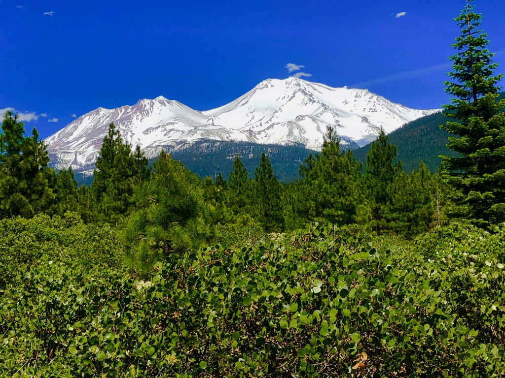
One of the main reasons The Gateway Trails are popular is that they are easily accessible. Sitting just outside the town of Mount Shasta, the main trailhead is minutes off of Interstate 5. For local hikers, bikers, and runners, it is mostly used for quick access to outdoor recreation and exercise. Alternatively, for visitors seeking relatively flat ground for a less strenuous day, it is fantastic for exploring the area’s beautiful scenery while enjoying excellent up close views of Mount Shasta and Black Butte, as well as more distant views of Castle Crags and other mountain peaks.
Lots of Options
Further, due to the interconnection of dirt/gravel roads with purpose built trails, the Gateway Trail System gracefully handles the heavier summer usage it receives. At three points, the main Gateway Trail intersects dirt/gravel roads. At Marley Junction and Gateway Crossings, it also intersects additional trails. The map link below clearly shows the many options.
The Gateway Trail Hike
Starting from the main trailhead off of Everette Memorial Highway, the dirt trail is easy to follow. Lined with lots of low vegetation and rock, the trail itself is neither overly rocky, technical, or steep. At times the vegetation surrounding the trail is quite open. When it is, it wows with striking “in your face” views of Mount Shasta. Additional peeks at Black Butte are equally lovely, as are views of distant mountain ranges. Since the trail never climbed above the tree line we stopped to admire the views whenever the trees allowed. Our early June hike here also included quite an abundance and variety of gorgeous wildflowers.
Because the Mount Shasta area is breathtaking and has so much to offer, it attracts a lot of attention. Many of the trails in and around Mount Shasta are heavily used, particularly in the summer. In contrast to our experiences hiking on some of these other trails, we met only a solo mountain biker on the Gateway Trail. It was a refreshing treat to have the Gateway Trail nearly all to ourselves. As such, we welcomed and appreciated the change of pace, solitude, and quiet we found on this trail.
Scroll down to learn about the GEAR WE USE and OTHER OUTVENTURES in this area.
Additional Information (Click below to follow link.)